|
Duplex Location |
Length (mi) |
Signed directions |
Existed |
| Blue Earth |
1.0 |
US 16 E-W |
ca. 1936-1978 |
|
Duplex Location |
Length (mi) |
Signed directions |
Existed |
| Blue Earth |
1.0 |
US 16 E-W |
ca. 1936-1978 |
Photographs
|
|
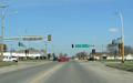
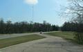
Around 1936, a construction project on the northeast side of Blue Earth realigned US 16 and US 169 onto that side of town, with the two routes having a common alignment for about 1 mile. This photo shows the eastern end of the former duplex. US 16 came from the right here and continued straight ahead with US 169. Photo by Adam Froehlig, taken April 17, 2007. |
|
|
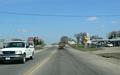
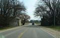
Near 3rd St in Blue Earth. Photo by Adam Froehlig, taken April 17, 2007. |
|
|
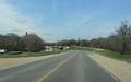
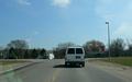
Along what is now westbound CSAH 16. This really old diamond interchange was built at the western US 16/US 169 junction ca. 1936. Photo by Adam Froehlig, taken April 17, 2007. |
|
|
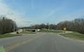
A closer view of the westbound off-ramp. US 169 exited from US 16 here to continue north towards Mankato. Photo by Adam Froehlig, taken April 17, 2007. |
|
|
Looking at the eastbound on-ramp. All of the ramps had these tight curves and both on-ramps had yield signs at the end of the ramp. Photo by Adam Froehlig, taken April 17, 2007. |
|
|
Eastbound CSAH 16 at what's left of an old railroad overpass for the old Chicago and Northwestern Railroad. Just beyond the overpass, where CSAH 16 now curves left to junction with US 169, the old US 16/169 curved to the right. Photo by Adam Froehlig, taken April 17, 2007. |
|
|
Where today's CSAH 16 intersects US 169. Photo by Adam Froehlig, taken April 17, 2007. |
Back to Minnesota Multiplexes
Back to Highway Photography
Last Updated: August 26, 2007
(C) 2007, Adam Froehlig