
Background:
This fictional freeway is a combination of two thoughts: the existing limited-access VA 199 around Williamsburg, and a ca.1989 proposal for an additional York River crossing.
Existing VA 199 runs from I-64/SR 646 at Exit 234, around the west and south side of Williamsburg, through Exit 242 at I-64 to end at SR 641 near Water Country, USA. Except for the interchange at I-64/SR 646 (a 6-ramp partial-cloverleaf), the first ~7 miles of VA 199 is freeway-grade. VA 199 is then a mix of 2-lane and 4-lane expressway from VA 5 West to just west of US 60, although the 2-lane segments have construction projects underway to widen them to 4 lanes. Existing VA 199 then has a short (~1 mile) freeway segment between US 60 and I-64 before the terminus at SR 641. My Fictional VA 199 simply upgrades the I-64/SR 646 interchange and the expressway segments to freeway, with interchanges at VA 5 West, VA 5 East/VA 31, VA 132/Colonial Pkwy, and SR 637/Quarter Path Rd.
In the late '80s, there was a conceptual proposal floated for a new high level bridge crossing of the York River between York County and Gloucester County. Roughly 30 miles separates the bridges on VA 33 at West Point from the US 17 Coleman Bridge at Yorktown, and this proposal would have provided a high capacity crossing between the two, serving as an alternate route to both bridges and an alternative to expanding the Coleman Bridge. In the early '90s, VDOT decided to proceed with widening the Coleman Bridge in lieu of building a new bridge, and this project was completed in 1996. My fictional VA 199 follows this conceptual York River Bridge crossing as a 4-lane freeway, with an interchange on the York County side at a relocated SR 641, and Gloucester interchanges at SR 614/Hickory Fork Rd and US 17/SR 615.
Map/Routing:
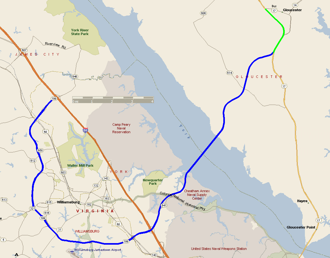
This map shows the location of my VA 199 fictional freeway overlaid on a modern-day map. Total length is about 24 miles. The freeway routing is represented in blue. Green reflects a related fictional upgrade of US 17 to freeway near Gloucester.
Route Log:
Mileage is based on the northern I-64/VA 199 interchange being Milepost 0, with mileage increasing going south then east.
| Milepost | Cross-street or feature | Access |
| 0 | I-64 | Interchange |
| x | Mooretown Rd | Interchange |
| x | US 60 | Interchange |
| x | SR 612/Longhill Rd | Interchange |
| x | VA 321/VA 5 West/Monticello Ave | Interchange |
| x | Old VA 5/John Tyler Hwy | Interchange |
| x | VA 5 East/VA 31 | Interchange |
| x | VA 132/Colonial Pkwy | Complex interchange |
| x | SR 637/Quarterpath Rd | Interchange |
| x | US 60/Pocahontas Tr | Interchange |
| x | VA 143/Merrimac Tr | Interchange |
| x | I-64 | Interchange |
| x | SR 641/Penniman Rd | Interchange |
| x | Colonial Pkwy | None |
| x | York River Bridge | N/A |
| x | SR 614/Hickory Fork Rd | Interchange |
| x | SR 615/Burleigh Rd | Half-interchange (W) |
| x | US 17/George Washington Hwy | Interchange |
Links (under development):
A VIRTUAL CRUISE of eastbound VA 199
A VIRTUAL CRUISE of westbound VA 199
Basic Exit List
Back to Fictional Freeways
Back to Magnolia Meanderings
Last Updated: November 6, 2004
(C) 2004 Adam Froehlig