Greenville Connector Route
The following is an article that I wrote for the city of Greenville, giving a brief description of the corridor study for the Greenville Connector Route, a proposed spur between future I-69 and the future US 82 Greenville Bypass.
The Greenville Connector Route is a proposed expressway-style connection between the future U.S. 82 Greenville Bypass and the proposed Interstate 69 extension. This route is being planned to tie the two interregional corridors together, improve the local/regional transportation network, and improve access to the various intermodel facilities and businesses in the Greenville area.
At the request of the City of Greenville and Washington County, a Corridor Study for the route was prepared by ABMB Engineers, Inc with assistance from W.L. Burle, Enginners, P.A. This corridor study, completed in May of 2000, will serve as the beginning stage for more intensive environmental and location studies for the planned route. The corridor study evaluated three possible corridors to determine the most favorable location for the route, and came up with a recommended corridor, a preliminary environmental inventory, and preliminary construction costs. Although the corridor study only considered a two-lane facility or a four-lane expressway facility, this does not preclude the possibility of constructing an Interstate-grade facility. In fact, some are touting this proposal as a possible Interstate spur, popularly dubbed "I-169".
Recommended Alternative
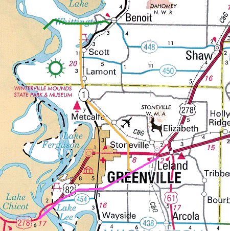
The recommended alternative, from south to north, begins at a point on the future U.S. 82 Greenville Bypass approximately 4.5 miles southwest of Leland. From this point, the corridor runs nearly due north, crossing existing U.S. 82 east of a significant mobile home park, and begins turning northwest while crossing the Columbus and Greenville Railroad. The corridor continues northwest, passing west of Metcalfe and east of Winterville Mounds State Park before tying into Mississippi Highway 1 about a mile south of the Washington/Bolivar County Line.
From here to just west of Scott, the corridor follows existing Highway 1. Preliminary findings indicate that the existing roadway can be upgraded to a four-lane facility with only minor impacts, although additional right-of-way would be required. After Highway 1 branches off towards Benoit, the recommended corridor continues due north, crossing the western end of Lake Bolivar and ending at proposed Interstate 69 roughly halfway between Benoit and the planned Great River Bridge.
Preliminary findings indicate that this recommended alternative would require relocation of four to five residences, all located near the future U.S. 82 bypass. It appears that no businesses will need to be relocated. In addition, considerable wetland mitigation may be required due to the crossing of Lake Bolivar. Because of this, an alternative alignment that utilizes Highway 1 all the way to proposed Interstate 69 was considered and included in the study. This alternative alignment is approximately 23.7 miles long, compared with 21.9 miles for the recommended corridor.

This image represents a map based on current plans. the yellow-orange line is the recommended corridor for the Greenville Connector Route. The purple line near the bottom from Leland to the river is the planned U.S. 82 Greenville Bypass and river bridge. The green line near the top represents proposed I-69 between Benoit and the Great River Bridge.
Estimated Construction Costs
The following estimated construction costs are based on 1998 construction price data obtained from MDOT, and inflated at 3% per year. A 20% contingency factor was also added to cover possible miscellaneous costs. The estimates include interchanges at I-69 and the US 82 bypasses, appropriate railroad/waterway bridges, and upgrade costs for the existing Highway 1 segment. These estimated figures do not include right-of-way purchase, design/engineering fees, wetland mitigation, and related costs. Estimates for an Interstate-grade facility were not computed.
| Roadway Option | Alignment | Total Estimated Cost |
| two-lane roadway | recommended alignment | $41.5 million |
| two-lane roadway | Highway 1 alternative | $29.6 million |
| four-lane expressway | recommended alignment | $86 million |
| four-lane expressway | Highway 1 alternative | $75.3 million |
Summary of Findings
This summary of findings comes from the Corridor Study:
"A potential corridor has been located which will provide a spur-type connection from Projected I-69 (Corridor 18) to the Greenville urban area. In addition, the route would also connect future I-69 to U.S. 82 and be a valuable link in the regional transportation network. By connecting the north-south I-69 to the east-west U.S. 82, local, statewide, and regional access would be enhanced."
"The Greenville area is home to several intermodel facilities strategically connecting this region to the state and nation by air, water, and rail transportation. Directly linking these facilities by land to an international trade route, provided by I-69, would be a fulfillment of the stated goals and mandates of Corridor 18 to promote and facilitate economic development and serve significant freight and person travel."
"For local and regional patrons, the highway would also provide a more direct route to the Mid-Delta Regional Airport. The connector would also encourage local development and stimulate local economy."
"Based on preliminary analysis, it appears the recommended corridor imposes only minor environmental impacts and creates a relatively small number of residential displacements. A four-lane facility would be most beneficial for the long term; however, constructing a two-lane facility while purchasing adequate right-of-way for a future four-lane facility would be a prudent alternative."
January 19, 2006 Update
The Delta Democrat Times ran an article on another public meeting regarding the "169 connector", being held on 1/19/06. Not really any new information within the article, although it proves that the connector between I-69 and Greenville is still being looked at and pursued.
The article makes one blatant error. The reporter claims that there will not be any interchanges along the proposed I-69 between the Mississippi River and Shaw, which isn't true. An interchange at MS 1 near Benoit has always been proposed with I-69.
Go back to Magnolia Meanderings
Go to Chris
Lawrence's I-69 pages
![]()
Page last modified 19 January, 2006