
Between the Downtowns
This page covers I-94 from the I-394 interchange near downtown Minneapolis to the eastern I-35E "Capitol Interchange" near downtown St. Paul. This section includes a short quarter-mile duplex with I-35E, and hidden duplexes with US 12 and US 52 along the entire length. Total length of this section is approximately 10.7 miles.
Description
The main corridor between the two Twin Cities downtowns, I-94 was constructed during the 1960s parallel to the then-important University Ave. Even back then, there were some controversies involved, particularly at Lowry Hill (which resulted in the tunnel), at Prospect Park (where local residents did not want the mass of interchange ramps that then-MHD had proposed), and in the St. Paul neighborhood of Rondo, which was a middle-class black neighborhood that was virtually wiped out by construction of I-94. Today, this portion of I-94 is an important and VERY congested corridor.
SEPTEMBER 2007 UPDATE: The collapse of the I-35W Mississippi River bridge has made the western portion of this corridor even more congested. As a temporary measure, MnDOT has restriped I-94 between I-35W and MN 280 to provide 4 lanes in each direction, utilizing narrower lane widths and some of the shoulder to accomplish this. The lane restripe has helped some with the congestion, though there is concern over the loss of shoulder. MnDOT has stated that I-94 will be restriped back to its previous configuration when the new/replacement I-35W bridge is completed. Several drivers have requested that MnDOT keep the 4-lane striped configuration after the I-35W bridge completion.
Roadway Configuration
Average Daily Traffic Counts
| Location | 1996 | 1998 | 2000 | 2002 | 2004 | 2006 | 10-yr '96-'06 Change |
| East of I-394 (Lowry Hill Tunnel) | 144,000 | 157,000 | 159,000 | 163,000 | 165,000 | 164,000 | +14% |
| East of Lyndale/Hennepin Ave | 180,000 | 197,000 | 199,000 | 208,000 | 211,000 | 190,000 | +6% |
| East of I-35W SOUTH | 140,000 | 157,000 | 160,000 | 158,000 | 157,000 | 156,000 | +11% |
| East of I-35W NORTH/MN 55 | 92,000 | 127,000 | 130,000 | 128,000 | 132,000 | 138,000 | +50% |
| East of 5th St | 112,000 | 149,000 | 152,000 | 159,000 | 148,000 | 150,000 | +34% |
| East of Cedar Ave | 125,000 | 160,000 | 164,000 | 163,000 | 163,000 | 161,000 | +29% |
| Between 25th/Riverside ramps | 107,000 | N/A | N/A | N/A | N/A | N/A | N/A |
| E of 25th/Riverside Ave (MS River) | 115,000 | 154,000 | 159,000 | 157,000 | 167,000 | 157,000 | +37% |
| E of Huron Blvd | 119,000 | 158,000 | 164,000 | 160,000 | 171,000 | 171,000 | +44% |
| Between MN 280 ramps | 103,000 | N/A | N/A | N/A | N/A | N/A | N/A |
| E of MN 280 | 138,000 | 168,000 | 172,000 | 168,000 | 170,000 | 171,000 | +24% |
| E of Cretin Ave/Vandalia St | 138,000 | 163,000 | 166,000 | 165,000 | 165,000 | 164,000 | +19% |
| E of MN 51/Snelling Ave | 134,000 |
149,000 |
156,000 |
157,000 |
159,000 |
159,000 |
+19% |
| E of Hamline Ave | 139,000 |
154,000 |
160,000 |
165,000 |
164,000 |
163,000 |
+17% |
| E of Lexington Pkwy | 139,000 |
159,000 |
160,000 |
164,000 |
164,000 |
162,000 |
+17% |
| E of Dale St | 144,000 |
160,000 |
162,000 |
165,000 |
170,000 |
171,000 |
+19% |
| E of Marion/Kellogg/5th/10th | 118,500 | 122,000 | 134,000 |
135,000 |
136,000 |
135,000 |
+14% |
| I-35E Duplex | 161,000 |
165,000 |
180,000 |
160,000 |
161,000 |
195,000 |
+21% |
1990 counts near downtown St. Paul and 1996 counts across the Mississippi are low due to construction.
Click HERE for the Exit List
Speed Limit
History
Future Plans
Froggie Suggests
Images (click on a thumbnail for a larger view)
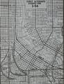 |
This early 1950s map shows some of the early routing alternatives for I-94 through or around downtown Minneapolis. An alignment similar to "Line A", along Washington Ave, is what was proposed in 1946. By 1957, I-94 was proposed more or less along its present-day alignment. |
Links
Last updated 24 May, 2008