
Background:
This fictional freeway is one of my own ideas, and represents what COULD have happened if Virginia Beach went about things differently over the years. Given that I-64 only has one interchange in Virginia Beach, the city has, in effect, no north-south freeways. Given that northern Virginia Beach is very developed, this makes those few north-south arterials that exist north of I-264 very popular with traffic. Three such arterials exist: Newtown Rd/Diamond Springs Rd (part of which is VA 166), Independence Blvd (VA 225), and Great Neck Rd (VA 279). Independence Blvd is the middle of the three.
With this in mind, plus the significant traffic problems along the corridor near I-264 and Pembroke Mall, I came up with this idea for a fictional freeway along the Independence Blvd corridor and running south to VA 165/Princess Anne Rd in the vicinity of Ferrell Pkwy. The idea for south of I-264 I got from a mid-1960s proposal for South Plaza Trail. In the mid-60s, when Virginia Beach's arterial system was first proposed, what was then proposed as a South Plaza Trail arterial would have run from South Independence Blvd near Mt. Trashmore southward to the Indian River Rd/Elbow Rd vicinity. This proposal disappeared by 1969 and eventually morphed into today's South Independence Blvd.
Map/Routing:
This map shows the location of my VA 225 fictional freeway overlaid on a modern-day map. Total length is roughly 8 miles. Blue represents the freeway routing, with green being a segment including C/D roads:
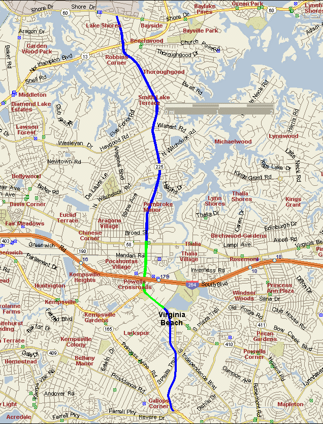 |
Starting from the north end, my VA 225 fictional freeway would begin at US 60/Shore Dr as a 4-lane freeway. The existing real-life cloverleaf at US 13/Northampton Blvd would be perpetuated. A half-diamond interchange to/from the south would take vehicles to/from Pleasure House Rd, and Shell Rd would tie into Pleasure House Rd here as well. |
| The northern section would have SPUI interchanges at Haygood Rd/Wishart Rd and Pembroke Blvd. | |
| Due to traffic issues and close proximity of interchanges, my fictional freeway includes C/D roads between US 58 Virginia Beach Blvd and where Holland Rd would split off in my universe. Through a tangled web of ramps, access would be provided at US 58/Virginia Beach Blvd, I-264, Baxter Rd/South Blvd, and Edwin Dr/Holland Rd. | |
| My fictional VA 225 splits off near Mt. Trashmore and heads southerly towards Princess Anne Rd. A partial interchange would exist at S. Plaza Trail and another half-diamond to/from the north at Salem Rd/Windsor Oaks Blvd before ending at a complex 4-way interchange with VA 165/Princess Anne Rd and my idea for a VA 407 freeway along Ferrell Pkwy. |
Route Log:
| Milepost | Cross-street or feature | Access |
| 0 | VA 165 South/VA 407 | Interchange |
| x | VA 165 North/Princess Anne Rd | Half-interchange (N) |
| x | Plaza Trail South | Partial-interchange |
| x | Edwin Dr/Holland Rd | Interchange |
| x | Baxter Rd/South Blvd | C/D Road |
| x | I-264 | Interchange |
| x | US 58/Virginia Beach Blvd | Interchange |
| x | VA 190/Pembroke Blvd | Interchange |
| x | Haygood Rd/Wishart Rd | Interchange |
| x | Shell Rd/Pleasure House Rd | Half-interchange (S) |
| x | US 13/Northampton Blvd | Interchange |
| x | US 60/Shore Dr ramps | At-grade intersection |
Links:
A VIRTUAL CRUISE of northbound VA 225
A VIRTUAL CRUISE of southbound VA 225
Basic Exit List
Back to Fictional Freeways
Back to Magnolia Meanderings
Last Updated: November 6, 2004
(C) 2004 Adam Froehlig