|
From: IA/MN State Line |
|
From: IA/MN State Line |
This fictional guide goes from south to north, as the mileposts do, so if you are heading southbound, go to the bottom and scroll up. It includes some stretches that are on existing real-life highways. I've included additional lanes on some stretches that I feel need them, as well as adding a couple routes and modifying a few interchanges. Mileages are rough and may not reflect actual mileage along the corridor. Route shields framed in blue indicate Exit List continuations (click on the shield to continue).
Northbound |
Southbound |
Interchange Type or Diagram |
Notes |
||||
 |
|
||||||
|
|
Osceola County |
Iowa Milepost 84 |
|||||
Exit 1
|
|
||||||
|
Nobles County |
|
Minnesota Milepost 0 |
|||||
Exit 4
SOUTH
|
|
Worthington Welcome Center |
|||||
Exit 6
|
|
Sportsman County Park EAST |
|||||
|
|||||||
Exit 10
|
(I-90 Exit 40)
|
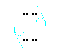
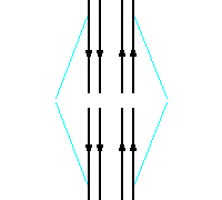
Trumpet interchange |
|||||
|
|
|
||||||
(I-90 Exit 42)
|
|
||||||
|
|||||||
(I-90 Exit 43)
NORTH
|
|
|
|||||
|
|
|
||||||
|
EAST
|
Exit 14AB
EAST
|
Cloverleaf interchange I-90 is "through route" |
|||||
|
|
||||||
Exit 21
|
|
||||||
|
Jackson County |
Nobles County |
Milepost 22.1 |
|||||
Exit 31
|
|
Sandy Point County Park SOUTHEAST |
|||||
Exit 38
|
|
||||||
|
Windom Next 3 Interchanges |
|
||||||
|
Des Moines River |
Milepost 42.6 |
||||||
Exit 42
SOUTH
|
Exit 42
SOUTH
|
|
Kilen Woods State Park SOUTHEAST |
||||
|
Cottonwood County |
Jackson County |
Milepost 42.8 |
|||||
|
|||||||
Exit 43
|
|
Cottonwood County Historical Museum |
|||||
|
|||||||
Exit 46
|
Exit 46 NORTH
|
|
|
||||
|
|
Windom Next 3 Interchanges |
||||||
Exit 48
TO |
|
||||||
Exit 55
|
|
Mountain County Park SOUTH |
|||||
|
Watonwan County |
Cottonwood County |
Milepost 58.2 |
|||||
Exit 61
|
|
||||||
St. James Next 3 Interchanges |
|
||||||
Exit 68
|
Exit 68
|
|
Ormsby SOUTH |
||||
|
Watonwan County Park SOUTH |
|||||||
Exit 70
|
|
|
|||||
Exit 73
|
Exit 73
|
|
|
||||
St. James Next 3 Interchanges |
|||||||
|
St. James Rest Area |
Milepost 76.0 |
||||||
|
|||||||
Exit 80
Expressway |
Trumpet
interchange |
||||||
|
|||||||
Madelia Next 3 Interchanges |
|||||||
Exit 84
|
Exit 84
|
|
|||||
|
Watonwan River |
Milepost 84.9 |
||||||
Exit 85
|
Exit 85
|
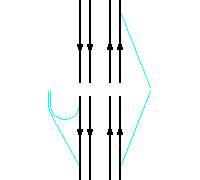
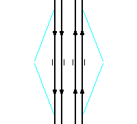
Folded diamond to SOUTH
Auxiliary lanes between Exit 85 |
|||||
|
|||||||
Exit 86
Expressway |
Trumpet
interchange |
||||||
|
|||||||
|
Blue Earth County |
Watonwan County |
Milepost 88.1 |
|||||
Exit 95
|
Southbound
ramps are diamond ramps
Auxiliary lanes between Exit 95 |
||||||
Exit 96
|
Exit 96
|
Tight diamond interchange |
|||||
|
|
||||||
Exit 101
SOUTH
|
Partial folded-diamond interchange
Auxiliary lanes between Exit 101 |
Vernon Center SOUTH |
|||||
|
Minneopa State Park NORTH |
|||||||
|
|||||||
Greater Mankato Area Next 9 Interchanges |
|||||||
Exit 103
|
Trumpet
interchange |
||||||
|
|
Milepost 104.0 |
|||||
Exit 105
|
Tight diamond interchange Climbing lane from SB on-ramp
Auxiliary lanes between Exit 105 |
Minneopa State Park WEST |
|||||
|
Blue Earth River |
Milepost 106.4 |
||||||
Exit 106 Old Riverfront Dr |
Half-diamond to/from SOUTH |
||||||
Exit 107A
|
Tight diamond interchange
Auxiliary lanes between Exit 107A |
Downtown Mankato EAST |
|||||
|
Nicollet County |
Blue Earth County |
Milepost 88.1 |
|||||
Milepost 109 Minnesota River Bridge |
|||||||
Exit 107BC
|
Exit 107B
|
Complex interchange
Half-diamond ramps to/from SOUTH Auxiliary lanes
between Exit 107BC |
|||||
Exit 108
|
Single-point urban interchange
Auxiliary lanes between Exit 108 |
||||||
Exit 109 Webster Ave |
Single-point urban interchange |
||||||
|
|||||||
|
|
Tight
partial-directional/cloverleaf |
Eagle Lake EAST |
|||||
|
|
||||||
Northbound |
Southbound |
Notes |
|||||
|
From:
|
![]()
Page last modified 09 May, 2008
 Fictional Exit Guide


 EAST
EAST
 WEST
WEST

 NORTH
NORTH