|
From:
|
|
From:
|
This fictional guide goes from south to north, as the mileposts do, so if you are heading southbound, go to the bottom and scroll up. It includes some stretches that are on existing real-life highways. I've included additional lanes on some stretches that I feel need them, as well as adding a couple routes and modifying a few interchanges. Mileages are rough and may not reflect actual mileage along the corridor. Route shields framed in blue indicate Exit List continuations (click on the shield to continue).
Northbound |
Southbound |
Notes |
|
 |
|
||
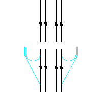
Exit 110AB
|
Tight
partial-directional/cloverleaf
Auxiliary lanes between Exit 110B |
Eagle Lake EAST |
|
|
|||
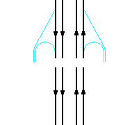
Exit 111
|
Tight diamond interchange |
 EAST EAST |
|
|
Greater Mankato Area Next 8 Interchanges |
||
|
|
Milepost 111.5 |
|
Exit 113 490th St |
|
||
St Peter Next 4 Interchanges |
|
||
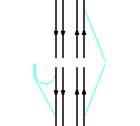
Exit 117
|
Half-directional interchange |
||
|
|
||
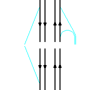
Exit 118
SOUTH
|
5-ramp partial-cloverleaf
interchange |
Cleveland EAST |
|
|
|||
Exit 120
|
|
Gustavus Adolphus College EAST |
|
|
|
||
Exit 121
NORTH
|
|
||
|
|||
Exit 124
|
Half-directional interchange |
||
|
St Peter Next 4 Interchanges |
||
|
|
St. Peter Rest Area |
Milepost 127.5 |
|
|
Sibley County |
Nicollet County |
Milepost 129.5 |
|
Exit 132
|
Exit 132
|
|
|
|
Le Sueur County |
Sibley County |
Milepost 129.5 |
|
Exit 132
|
Folded-diamond interchange to NORTH NB
truck-climbing lane from |
||
|
Le Sueur Hill Rest Area |
|
Milepost 127.5 |
|
Exit 137
|
|
Gaylord WEST |
|
|
Henderson Station County Park WEST |
|||
|
Scott County |
Le Sueur County |
Milepost 137.7 |
|
Exit 140
|
|
Minnesota Valley State Park WEST |
|
Exit 144
|
|
||
Exit 145
|
|
||
Exit 147
|
|
Minnesota Valley Trail, |
|
Exit 150
|
|
||
Exit 152
TO |
Exit 152A
|
|
Minnesota Valley Trail, |
Exit 152B
|
Partial-directional
interchange |
||
Exit 155
|
|
||
Exit 157
|
|
Minnesota Rennaisance Festival WEST |
|
Exit 159
|
Partial folded-diamond
interchange C/D
roads between Exit 159 |
Old
|
|
Exit 160
|
3-way semi-directional interchange
C/D roads between Exit 160 6 lanes north of MN 41 |
||
Exit 161
|
Diamond interchange |
||
|
Shakopee |
|
Milepost 161.3 |
|
Exit 162
|
Folded diamond to NORTH(EAST) |
||
Exit 163
|
|
|
|
Exit 165
|
Diamond interchange Auxiliary
lanes between Exit 165 |
ValleyFair WEST(NORTH) |
|
|
|
Milepost 166.5 |
|
|
|||
Exit 168AB
EAST |
On-ramp from
|
West
end of complex Half-directional to/from SOUTH 4 lanes northeast of MN 133 |
|
|
On-ramp from
|
Exit 168B
|
Middle of
comple
Trumpet
interchange 6 lanes northeast of MN 142 |
|
On-ramps from
|
Exit 168AC
EAST
|
North
end of complex
Half-interchange to/from NORTH
Auxiliary lanes between Exit 168C |
|
|
Bloomington Ferry Bridge |
Milepost 168.8-169.9 |
||
|
Eden Prairie/Bloomington |
Shakopee |
Milepost 169.5 |
|
|
Eden Prairie/Bloomington City Limits along freeway between Minnesota River and Milepost 173.0 |
|||
Exit 170
|
Diamond interchange Auxiliary
lanes between Exit 170 |
||
Exit 171
|
Diamond interchange |
||
Exit 172
Anderson Lakes Pkwy |
Partial
folded-diamond interchange
Auxiliary lanes between Exit 172 |
||
|
Anderson Lakes |
Milepost 172.7-172.8 |
||
|
|
Milepost 173.0 |
|
Exit 173A
Marth Rd |
|
Half-diamond interchange |
|
|
|||
Exit 173BC
|
Partial-directional/cloverleaf |
|
|
|
|
||
Northbound |
Southbound |
Notes |
|
|
From:
|
![]()
Page last modified 09 May, 2008
 Fictional Exit Guide


 NORTH
NORTH


 EAST
EAST


 Int'l Airport EAST