
South Metro (outside the Beltway)
This page covers I-35E from the I-35W/I-35E split in Burnsville to the I-494 interchange in Eagan. Total length of this section is approximately 11.3 miles.
Description
One of the newer Interstate segments in the Twin Cities metro, this section of I-35E was opened up in stages between 1980 and 1986. With close to 30 years of insight into freeway design by that time, this is also one of the better designed freeways within the Metro. Although traffic volumes are increasing, this section of I-35E remains relatively free-flowing, even during rush hour. An I-35E/MN 77 combination serves as a good alternative to I-35W through Burnsville and Bloomington, although the MN 77 Minnesota River bridge can get congested during peak periods. This section of I-35E also serves as a good "lower-traffic" through route for through traffic traveling I-35.
Roadway Configuration
Average Daily Traffic Counts
| Location | 1982 | 1984 | 1986 | 1988 | 1990 | 1992 | 1994 |
| N of I-35/I-35E | 7,300 | 6,900 | 7,600 | 13,500 | 17,500 | 17,500 | 21,000 |
| N of CSAH 42 | 8,700 | 11,500 | 15,700 | 24,500 | 29,000 | 32,000 | 35,000 |
| N of CR 11 | 11,600 | 14,500 | 24,000 | 32,500 | 38,000 | 38,000 | 46,000 |
| N of MN 77 | N/A | N/A | 19,500 | 30,000 | 33,000 | 39,000 | 46,000 |
| N of Cliff Rd | N/A | N/A | 22,500 | 35,500 | 39,500 | 45,500 | 51,000 |
| N of Diffley Rd | N/A | N/A | 23,600 | 37,000 | 41,500 | 47,000 | 53,000 |
| N of Pilot Knob/Yankee Doodle | N/A | N/A | 26,500 | 45,500 | 50,000 | 50,000 | 70,000 |
| N of Lone Oak Rd | N/A | N/A | 29,500 | 51,900 | 57,000 | 62,000 | 82,000 |
| Location | 1996 | 1998 | 2000 | 2002 | 2004 | 2006 | 10-yr '96-'06 Change |
| N of I-35/I-35E | 23,500 | 26,500 | 37,000 | 41,000 | 43,000 | 39,000 | +66% |
| N of CSAH 42 | 39,500 | 40,000 | 47,500 | 50,000 | 52,000 | 53,000 | +34% |
| N of CR 11 | 50,000 | 52,000 | 59,000 | 61,000 | 63,000 | 63,000 | +26% |
| N of MN 77 | 48,000 | 53,000 | 62,000 | 66,000 | 68,000 | 69,000 | +44% |
| N of Cliff Rd | 55,000 | 62,000 | 70,000 | 74,000 | 77,000 | 74,000 | +35% |
| N of Diffley Rd | 58,000 | 66,000 | 72,000 | 75,000 | 79,000 | 79,000 | +36% |
| N of Pilot Knob/Yankee Doodle | 72,000 | 83,000 | 93,000 | 97,000 | 100,000 | 100,000 | +39% |
| N of Lone Oak Rd | 79,000 | 92,000 | 103,000 | 104,000 | 107,000 | 107,000 | +35% |
Opened between I-35/I-35E and MN 77 in 1982.
Opened between MN 77 and I-494 in late 1985. 1986 counts
reflect this.
Click HERE for the Exit List
Speed Limit
History
Future Plans
Froggie Suggests
Images (click on a thumbnail for a larger view)
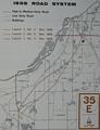 |
This 1958 map shows 3 alternate routings for I-35E between I-35/I-35W in Burnsville and I-494 in Eagan. A routing similar to Alt 2, but curving east of Blackhawk Lake, was ultimately selected. |
Links
Last updated 24 May, 2008