
Hennepin County
This page covers I-394 in its entirety from the I-394/I-494/US 12 interchange in Minnetonka to I-394's eastern end at Washington Ave N in downtown Minneapolis. This includes a roughly 8.7 mile duplex with US 12. Total length of this section is approximately 9.7 miles.
Description
I-394 is the latest addition to the Interstate system in Minnesota. Originally designated in 1968 over what was then a 4-lane US 12/Wayzata Blvd corridor, construction did not begin until the mid '80s, and took nearly 10 years to complete. I-394 is significant in that transit played a key part in its design. There are many "firsts" associated with I-394, even today. The route was the first one in Minnesota to include HOV lanes, special lanes reserved for carpools, vanpools, buses, and motorcycles during rush hour. It is also the first (and so far only) route to include a separated, reversible section. It is now also the first route in Minnesota to have HO/T lanes, whereby solo drivers can pay a toll to use the often-underutilized HOV lanes.
Although still decried by some, I-394's design is much more efficient and greatly improved over the old US 12 design, and plays an important part in the Twin Cities transportation system.
Roadway Configuration
6 lanes from I-494 to US 169
7 lanes (3 eastbound, 4 westbound) from US 169 to just west of MN 100
4 through lanes through the MN 100 interchange
6 lanes from MN 100 to I-94
4 through lanes from I-94 to 4th/5th Sts
2 lanes from 4th/5th Sts to Washington Ave
Inside lanes between I-494 and just west of MN 100 are HO/T lanes (HOV-2 + solo toll), 6-10am EB, 2-7pm WB
2-lane reversible HO/T lanes from just west of MN 100 to just east of I-94
Reversible HO/T lanes have direct connections to MN 100, Dunwoody Blvd, and I-94 East
*NO* access from Reversible HO/T lanes to Penn Ave or I-94 West
C/D roads at I-494, US 169/General Mills Blvd, and Xenia Ave/MN 100
NO access to Ridgedale Dr from Plymouth Rd EB on-ramp
NO WB on-ramp at Ridgedale Dr
Auxiliary lanes between all interchanges, EXCEPT between MN 100 and Penn Ave
Average Daily Traffic Counts
| Location | 1980 | 1982 | 1984 | 1986 | 1988 | 1990 | 1992 | 1994 |
| E of I-494 | 43,000 | 44,800 | 51,100 | 52,700 | 42,500 | 47,500 | 77,000 | 83,000 |
| E of Plymouth Rd | 37,300 | 37,800 | 45,800 | 47,100 | 41,000 | 53,000 | 73,000 | 78,000 |
| E of Ridgedale Dr | 40,500 | 40,000 | 47,000 | 47,800 | 46,500 | 53,000 | 88,000 | 88,000 |
| E of CSAH 73 | 42,000 | 42,200 | 48,500 | 49,100 | 49,500 | 53,000 | 89,000 | 95,000 |
| E of US 169 | 43,400 | 51,200 | 54,600 | 55,200 | 52,000 | 47,500 | 95,000 | 105,000 |
| E of Winnetka Ave | 47,200 | 50,100 | 54,000 | 53,000 | 54,000 | N/A | N/A | N/A |
| E of Louisiana Ave | 51,200 | 53,100 | 55,000 | 56,000 | 55,000 | 50,000 | 96,000 | 109,000 |
| W of Vernon Ave | 52,500 | N/A | N/A | 57,900 | N/A | N/A | N/A | N/A |
| E of Vernon Ave | 57,500 | 58,100 | 65,800 | 69,200 | 65,000 | 60,000 | 76,000 | 75,000 |
| E of MN 100 | 82,500 | 82,800 | 87,400 | 92,000 | 87,000 | 81,000 | 101,000 | 126,000 |
| E of Wirth Pkwy | 79,000 | 79,500 | 86,000 | 94,300 | 89,000 | 83,000 | N/A | N/A |
| E of Penn Ave | 76,500 | 76,800 | 91,000 | 100,000 | 93,000 | 86,000 | 102,000 | 128,000 |
| E of Dunwoody Blvd | 60,000 | 64,100 | 79,400 | 87,000 | 79,500 | 72,000 | N/A | N/A |
| E of I-94 | N/A | 8,500 | 31,500 | 24,600 | 22,000 | 26,000 | 30,000 | 41,500 |
| Location | 1996 | 1998 | 2000 | 2002 | 2004 | 2006 | 10-yr '96-'06 Change |
| E of I-494 | 96,000 | 98,000 | 100,000 | 101,000 | 100,000 | 101,000 | +5% |
| E of Plymouth Rd | 84,000 | 95,000 | 98,000 | 96,000 | 98,000 | 95,000 | +13% |
| E of Ridgedale Dr | 99,000 | 110,000 | 113,000 | 112,000 | 113,000 | 110,000 | +11% |
| E of CSAH 73 | 99,000 | 113,000 | 118,000 | 116,000 | 118,000 | 114,000 | +15% |
| E of US 169/Gen. Mills Blvd | 115,000 | 124,000 | 132,000 | 131,000 | 132,000 | 129,000 | +12% |
| E of Louisiana Ave | 119,000 | 129,000 | 134,000 | 133,000 | 134,000 | 132,000 | +11% |
| E of Vernon Ave | 83,000 | 121,000 | 134,000 | 133,000 | 134,000 | 132,000 | N/A |
| E of MN 100 | 135,000 | 143,000 | 145,000 | 142,000 | 151,000 | 148,000 | +10% |
| E of Penn Ave | 137,000 | 148,000 | 148,000 | 147,000 | 147,000 | 143,000 | +4% |
| E of I-94 | 44,800 | 50,000 | 51,000 | N/A | 48,000 | 48,000 | +7% |
| E of 12th St | 26,500 | 34,000 | 32,000 | 29,000 | 29,000 | 29,000 | +9% |
| E of 6th St | 7,200 | 8,600 | 20,000 | 20,000 | 20,000 | 20,000 | +278% |
Traffic volumes prior to about 1992 reflect the pre-394 US 12
expressway.
Traffic volumes for "E of Vernon" include C/D
roads for 1998 and later, and are mainline only prior to 1998.
Click HERE for the Exit List
Speed Limit
History/Timeline
NOTE: Between I-494 and I-94, I-394 was constructed along the right-of-way of the then-existing US 12 expressway. Only east of about 12th St was new road actually built. All construction dates listed below are approximate.
Additional history from a 1975 study is located on this page.
Future Plans
Froggie Suggests
Images (click on a thumbnail for a larger view)
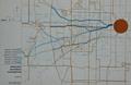 |
This map, from the ca. 1971 I-394 Corridor Report, shows the seven
alignment alternatives initially considered for I-394.
|
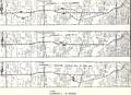 |
The original seven alternatives (plus an eighth "do nothing option")
from the ca. 1971 corridor report were later refined into these three
alternatives (plus the "do nothing option"). It should be noted
that the 1973 Draft EIS did not show the alignment split near Ridgedale
as shown in Alternative 1 here. Instead, the Draft EIS showed
Alternative 1 along existing US 12 in that area.
|
|
|
These three transit alternatives were studied in the Draft EIS in 1973. Two alternatives proposed "exclusive transit facilities", though it's unclear whether they would have been rail transit or a BRT-type of system. The third alternative recommended "preferential bus treatment" along both I-394 and MN 55 and a pair of Reversible HOV lanes in the middle of I-394. |
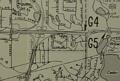 |
This map clipping, from a 1974 book on the status of Minnesota's Interstate
highways, shows a proposed half-interchange on I-394 at France Ave, on the
Minneapolis/Golden Valley border near the Target Financial Services (formerly
Prudential) building. An extension of France Ave to the south to meet
existing France Ave near the Irving Ave/W 22nd St intersection was part of the
plan. A related county project would have filled in the France Ave gap
between Lake St and Excelsior Blvd. The I-394 Draft EIS, dated 1973, did not show this interchange in any of the alternatives. Nor did it appear in the 1981 Final EIS. So it presumably was proposed only during the mid-late 1970s and was subsequently dropped before construction began. |
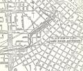 |
This ca. 1975 map, from the Study Report on Uncompleted Interstate Segments in the Twin Cities Metropolitan Area, shows the 3rd Ave Distributor as it was proposed at the time. Note the three parking garages that are proposed, and that what became the 7th St Garage was not originally proposed in the air rights above I-394. |
Links
![]()
Page last modified 12 May, 2008