
North Minneapolis
This page covers I-94 from the I-94/694 split in Brooklyn Center to the I-394 interchange near downtown Minneapolis. This section includes a hidden duplex with US 52 along the entire length. Total length of this section is approximately 7.1 miles.
Description
This segment of I-94 is the main gateway to downtown Minneapolis from the north and northwest. It includes one of the newer segments of I-94, fully opening in 1982, and incidentally is the last 8-through-lane corridor built in the Twin Cities, as federal regulations were changed shortly after its design, limiting new Interstates to 6 through lanes. Fortunately, due to its width and improved design (unlike most of the Twin Cities freeways), this section is relatively free-flowing.
Roadway Configuration
Average Daily Traffic Counts
| Location | 1996 | 1998 | 2000 | 2002 | 2004 | 2006 | 10-yr '96-'06 Change |
| Between I-694 and MN 252 | 45,000 | 49,000 | 51,000 | 53,000 | 53,000 | 58,000 | +29% |
| South of MN 252 | 109,000 | 116,000 | 117,000 | 122,000 | 122,000 | 123,000 | +13% |
| South of 53rd Ave N | 100,000 | 108,000 | 110,000 | 115,000 | 114,000 | 115,000 | +15% |
| South of 49th Ave N | 110,000 | 120,000 | 120,000 | 126,000 | 126,000 | 126,000 | +15% |
| South of Dowling Ave N | 116,000 | 125,000 | 126,000 | 134,000 | 134,000 | 140,000 | +21% |
| South of 3rd/4th St ramps | 75,000 | 85,000 | N/A | N/A | N/A | N/A | N/A |
| South of West Broadway | 115,000 | 126,000 | 110,000 | 118,000 | 117,000 | 115,000 | 0% |
| South of MN 55/7th St | 128,000 | 140,000 | 120,000 | 118,000 | 118,000 | 115,000 | -10% |
Click HERE for the Exit List
Speed Limit
History
Additional history from a 1975 study is located on this page.
Future Plans
Froggie Suggests
Images (click on a thumbnail for a larger view)
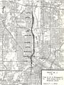 |
This ca. 1975 map, from the Study Report on Uncompleted Interstate Segments in the Twin Cities Metropolitan Area, shows the proposal for I-94 as it existed at the time. Except for adding a full interchange at West Broadway and direct ramps to/from 3rd/4th Streets in downtown, this version is largely what was built. |
Links
![]()
Page last modified 12 May, 2008