Hennepin Line (fantasy transit)
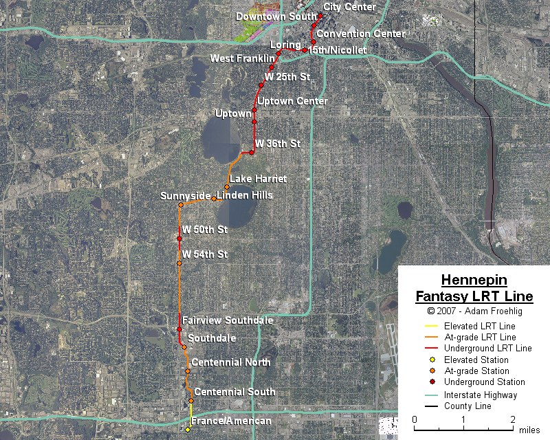
The premise behind this line was a brainstorming session behind how to best get a transit line running between Uptown Minneapolis and Downtown Minneapolis. The most direct routing, along Hennepin Ave, also happens to be one of the most congested streets within the city. Though the street is the typical Minneapolis arterial width, it's limited to 4 lanes plus parking lanes. Getting an at-grade LRT or streetcar line through would at a minimum require eliminating parking, and would also muck up what is already significant delay at the existing traffic signals along the corridor.
The best way I could think of to accommodate this line is to put it underground, at least from the Uptown area north into downtown. There are small urban core pockets to the south and southwest, leading to the Southdale area, that could also benefit from a consistent rail transit connection, and so my idea for the Hennepin Line extends southward through these small urban cores. Through the Southdale/Centennial Lakes area, the line is partly influenced by city of Edina proposals for redevelopment and a local transit line through the area.
Beginning at the Minneapolis Convention Center station, where it splits off of the Lakeville line, the Hennepin line loops westward to the 15th St/Nicollet Ave intersection. It then follows underneath 15th St west to near Oak Grove St, where it begins a looping curve to the southwest, underneath the I-94 Lowry Hill Tunnel and then following underneath Hennepin Ave to the southwest. At W 36th St it curves west, following underneath W 36th St to near the W 36th St/Lake Calhoun Pkwy intersection, where it curves southwest and returns to grade.
South of W 36th St, it follows the historic trolley line along the east side of Lake Calhoun Pkwy and the west side of Lake Harriet, then continues through the Linden Hills area along the old Harriet streetcar alignment, which is still relatively intact. This alignment continues to near W 44th St/Abbott Ave, where the line curves to follow W 44th St. At Sunnyside Ave, the line turns briefly southwest before turning south along France Ave.
Due to the relative narrowness of France Ave between 44th St and MN 62, the line generally has streetcar characteristics through here, except between 48th St and 52nd St where the line tunnels under France Ave. Near 62nd St, the line goes into another tunnel, passing underneath the MN 62/France Ave interchange and the 66th St/France Ave intersection before curving southeast and coming back to grade on the southwest side of Southdale.
South of Southdale, the line passes through the southwest parking lots, then crosses W 69th St and cuts south through the Galleria (two of the city's three concepts for the area include this cut-through). South of W 70th St, the line uses an existing park corridor parallel to and about halfway between France Ave and York Ave. The line briefly turns east at Parklawn Ave, then south onto Edinborough Way. The line crosses over I-494 onto Southtown Dr, still elevated, then ends at an elevated station along American Blvd just east of France Ave.
Besides the Convention Center, stations would be provided at the following:
The following map shows the routing of my fantasy Hennepin LRT line:
Back to my fantasy Twin Cities Light Rail Transit
Back to Twin Cities fantasy transit system
Go to my suggested
freeway/expressway changes.
Go to my ideas for improving/upgrading Twin Cities area
interchanges.
Return to Twin Cites Highways
![]()
Page last modified 23 December, 2007