Lakeville (I-35W) Line (fantasy transit)
The idea for this line initially came from the I-35W studies of the mid-90s (which proposed an LRT line down to 95th St, but was cancelled due to lack of funds). I took that line as a base and tweaked it around to provide what I think would be a viable commute route and a replacement for the BRT/HOV lanes proposed for I-35W. As my fantasy Nicollet streetcar line would handle local transit needs along the corridor, I've geared the Lakeville line more towards commuters and longer-distance transit users.
Some earlier studies called it the "35W" or "South" line. My initial fantasy system also called in the "I-35W Line". As I have extended it down into the heart of Lakeville, I've used that city as the name for the line.
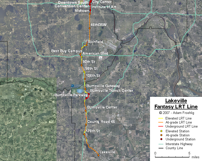
Starting at the Minneapolis Convention Center station, where the Hennepin Line splits off, the line cuts south directly underneath the Convention Center, meeting 3rd Ave underneath I-94. The line continues south underneath 3rd Ave for about a mile until approaching I-35W. The line passes underneath the southbound I-35W lanes and comes up to grade in the I-35W median just north of 29th St and the Progressive Rail right-of-way.
South of 29th St, the line would run in the I-35W median south to the Progressive Rail RR line located between Nicollet and Lyndale Aves. The line would go below the I-35W grade about a block west of Nicollet in order to meet the RR alignment. The line would only briefly follow the RR alignment before turning west along the north side of 66th St, bridging over Lyndale Ave then bridging over 66th St near Bridgeman's. The line would then follow the northwestern boundary of Wood Lake Park southwest to I-35W, bridge over I-35W, and follow the west side of I-35W (along Humboldt Ave) to about 76th St. There would be a short tunnel underneath 76th St before the line follows the east side of the Best Buy campus, and tunnels under I-494.
South of I-494, the line cuts southeast back to the I-35W ROW near American Blvd, passing underneath American Blvd, the southbound off-ramp to 82nd St, and 82nd St itself. The line then bridges over the southbound I-35W lanes before returning to grade in the I-35W median. The line follows the I-35W median to the Progressive Rail RR overpass where it begins an elevated section to the southeast, crossing over the I-35W northbound lanes, 98th St, and then coming back down to grade on Lyndale Ave just south of 99th St. The line follows Lyndale Ave south all the way to the Minnesota River, and crosses over the river on structure along the east side of I-35W.
South of the river, the line follows the east side of I-35W, passing east of the proposed 118th St interchange (which is part of the Burnsville Gateway project). At 121st St, the line begins to go elevated before breaking off to the southeast, bridging over Cliff Rd and the UP RR line, and combating the river bluff by going underground enroute to the MN 13/Nicollet Ave intersection. The line, still underground, then turns southwest before breaking back to grade just southwest of the Burnsville Pkwy/Harriet Ave intersection, where the line then bridges over I-35W and follows the west side of I-35W to just north of CSAH 42, where the line goes underground again to cross under CSAH 42 and return to grade in the parking lots on the east side of Burnsville Center. South of Burnsville Center, the line cuts over to follow the west side of I-35 along Buck Hill Rd and then Kenyon Ave, with a bridge over Southcross Dr, tunnels under Crystal Lake Rd and CSAH 46, and a bridge over CSAH 5. South of CSAH 5, the line crosses under I-35 and follows the CP RR (with a bridge over CSAH 60/185th St) to "downtown" Lakeville where the line ends.
Instead of a station at Lake St, I would instead have a station at 29th St, in order to provide connections to my fantasy Midtown Line.
South of the Convention Center, stations would be provided at the following:
The following map shows the routing of my fantasy Lakeville LRT line:
Back to my fantasy Twin Cities Light Rail Transit
Back to Twin Cities fantasy transit system
Go to my suggested
freeway/expressway changes.
Go to my ideas for improving/upgrading Twin Cities area
interchanges.
Return to Twin Cites Highways
![]()
Page last modified 24 December, 2007