Mississippi Highway 15
|
Northern Terminus: |
Mississippi/Tennessee State Line north of Walnut, Tippah County |
|
Southern Terminus: |
At US 90 in Biloxi, Harrison County |
|
Distance: |
328.2 miles |
|
Counties Served: |
Harrison, Stone, Perry, Jones, Jasper, Newton, Neshoba, Winston, Choctaw, Webster, Oktibbeha, Chickasaw, Pontotoc, Union, Tippah |
|
Cities/Towns Over 5,000 Population: |
Biloxi, D'Iberville, Laurel, Philadelphia, Louisville, New Albany, Ripley |
|
Highway Duplexes: |
I-110, MS 42, US 84, I-59, MS 21, MS 16, MS 19, MS 25, US 82, MS 50, MS 32, MS 30, MS 2 |
|
Freeway segments: |
Along duplex with I-110 Along duplex with I-59 |
|
Multilane segments: |
From I-10 to 0.5 mile north From I-59 to the north side of Laurel From US 80 to I-20 in Newton From MS 488 to MS 16/19 in Philadelphia From MS 25 South to 2 miles north of MS 25 North Along duplex with US 82 Through Pontotoc |
|
National Highway System: |
Along duplexes with I-110, I-59, US 84, MS 25, and US 82 |
|
MDOT's Vision 21 System: |
Low Priority from US 90 to D'Iberville/Exit 2 High Priority from D'Iberville/Exit 2 to MS 25 South (excluding I-59 and US 84 duplexes) High Priority from 2 miles north of MS 25 North to MS/TN State Line (excluding US 82 duplex) |
Average Annual Daily Traffic Ranges (2004)
|
Harrison County |
10,000 (N of I-10/I-110) 3,000 (N of Old MS 67) 2,300 (S of Posey Bridge Rd) 1,300 (near Cedar Hammock Rd) 940 (N of Bethel Rd) 650 (N of Railroad Bridge Creek Rd) |
|
Stone County: |
650 (N of Wire Rd) 470 (NW of Pat Hickman Rd) |
|
Perry County |
3,900 (N of MS 198) 2,000 (N of Arlington Rd) 2,000 (N of Hintonville) 7,500 (along MS 42 duplex in Richton) 3,900 (N of Whitfield Rd) 2,300 (N of Good Hope) |
|
Jones County |
1,900 (near Perry/Jones Co Line) 2,000 (near Rd 270) 3,000 (N of George Boutwell Rd) 4,900 (N of Morning Dew Rd) 9,200 (N of Free St near Laurel) |
|
Jones County |
29,000 (near W 3rd St in Laurel) 29,000 (N of W 7th St in Laurel) 26,000 (N of 15th St in Laurel) 19,000 (near Parker Dr in Laurel) 15,000 (near Bush Dairy Rd in Laurel) 13,000 (near Parkwood Dr in Laurel) 7,600 (near Trace Rd) 6,300 (N of Springhill Rd) |
|
Jasper County: |
6,300 (N of CR 8) 6,000 (N of MS 533) 8,200 (S of MS 528 in Bay Springs) 8,100 (near School Rd in Bay Springs) 3,200 (near CR 1533) 2,900 (N of CR 504) 2,600 (S of Montrose) 1,900 (N of Montrose) 1,800 (S of CR 24) 1,800 (near Jasper/Newton Co Line) |
|
Newton County: |
1,800 (S of MS 504) 2,700 (S of Bethel Roberts Rd) 3,300 (N of Bethel Roberts Rd) 2,700 (S of Wickware Rd) 3,300 (N of Wickware Rd) 4,800 (N of Bell St/Airport Rd in Newton) 13,000 (N of US 80 in Newton) 10,000 (N of Sand Springs Church Rd) 5,700 (N of Decatur-Stratton Rd) 4,600 (S of MS 494) 4,800 (MS 494 to MS 492) 5,200 (MS 492 to Newton/Neshoba Co Line) |
|
Neshoba County: |
3,900 (N of CR 262) 5,200 (N of CR 321) 5,100 (S of MS 485) 7,100 (S of MS 21 West) 19,000 (S of MS 16/19 East) 8,600 (MS 16/19 East to MS 19 North) 4,400 (N of MS 19 North) 6,300 (S of CR 571) |
|
Winston County: |
4,800 (near Neshoba/Winston Co Line) 5,200 (S of MS 395/MS 490 in Noxapater) 4,900 (N of MS 395/MS 490 in Noxapater) 4,700 (near Lighthouse Church Rd) 3,700 (S of Smyth Lake Rd) 4,500 (S of MS 14) 6,400 (N of MS 14) 2,400 (N of MS 25 North) 2,200 (near Shelley Brown Rd) |
|
Choctaw/Webster |
3,200 (near Choctaw Lake Rd) 1,700 (N of Mabus Rd) 1,800 (near Pinnix Rd) 2,600 (near Choctaw/Webster Co Line) 4,100 (S of US 82 in Mathison) |
|
Webster/Oktibbeha |
3,800 (SW of Maben) 3,500 (N of Maben) 2,000 (N of MS 50 East) 1,700 (N of MS 50 West) 2,700 (near Webster/Chickasaw Co Line) |
|
Chickasaw County: |
2,200 (near Webster/Chickasaw Co Line) 2,500 (S of MS 340) 3,300 (near CR 63) 1,700 (S of Airport Rd) 3,300 (N of MS 8) 8,300 (S of MS 32 East) 5,000 (N of CR 18) 3,200 (N of MS 32 West) |
|
Pontotoc County: |
2,400 (near Chickasaw/Pontotoc Co Line) 3,500 (N of CR 114) 4,800 (N of CR 124) 10,000 (N of MS 41) 14,000 (N of MS 336 in Pontotoc) 10,000 (near CR 833) 8,200 (near CR 230) |
|
Union County: |
8,200 (S of CR 101) 8,200 (near CR 88) 8,200 (S of US 78) 11,000 (N of US 78 in New Albany) 10,000 (N of MS 348 in New Albany) 8,000 (N of 4th St) 4,500 (N of CR 82) |
|
Tippah County: |
5,000 (near CR 830) 8,100 (near S Line St) 9,400 (SW of Pontotoc Rd in Ripley) 13,000 (S of MS 4 in Ripley) 13,000 (N of E Pine St in Ripley) 12,000 (near Martin St in Ripley) 6,500 (N of CR 410) 4,100 (S of Tiplersville) 5,000 (N of CR 312) 3,600 (S of CR 102) |
Current/Upcoming Projects Listed in the STIP
|
Year: |
Location: | Type of Work: | Funding: |
|
2005 |
Kings Creek (S of New Albany) to Union/Tippah Co Line | ROW for 4-lane widening | $6.5 million |
|
2005 |
Union/Tippah Co Line to 1mi N of MS 4 | ROW for 4-lane widening | $5.3 million |
|
2005 |
1mi N of MS 4 to N of Falkner | ROW for 4-lane widening | $4.65 million |
|
2006 |
Laurel to Jones/Jasper Co Line | ROW for 4-lane widening | $3.50 million |
|
2006 |
Jones/Jasper Co Line to Stringer | ROW for 4-lane widening | $5.0 million |
|
2006 |
Kings Creek (S of New Albany) to Union/Tippah Co Line | 4-lane widening | $15.0 million |
|
2007 |
0.5mi N of US 80 to S end of Union bypass | ROW for 4-lane widening | $6.0 million |
|
2007 |
S end of Houston Bypass to MS 32 East | ROW for 4-lane widening | $3.0 million |
|
2007 |
MSU Experimental Station to MS 76 | PE for 4-lane widening | $500,000 |
|
2007 |
MS 76 to Pontotoc/Union Co Line | ROW for 4-lane widening | $3.325 million |
|
2007 |
Pontotoc/Union Co Line to Kings Creek (S of New Albany) | ROW for 4-lane widening | $3.325 million |
|
2007 |
Union/Tippah Co Line to 1mi N of MS 4 | 4-lane widening | $15.0 million |
|
2007 |
1mi N of MS 4 to N of Falkner | 4-lane widening | $20.0 million |
Froggie's Notes:
- MS 15 is billed as
being the longest state highway route in Mississippi, well over 300 miles in
length.
- The route is also known for having a considerable gap in it, even though the
gap did not exist in the early days of MS 15. I'm not sure when this
segment was decommissioned, but from MS 26 north to US 98 used to be part of a
continuous MS 15, and even had a duplex with MS 29.
- All of MS 15 was added to the former 1987 Highway Program as part of Phase 4,
with the goal of having a fully 4-laned MS 15 corridor throughout the state.
This carried over into the Vision 21 program, with the route having a
legislatively-mandated "High Priority" status.
- Although the highway is part of Vision 21, there has been previous work done
on the route over the last 3 decades. This includes full or partial
bypasses of Newton, Union, Philadelphia, Louisville (with MS 25), and Houston,
as well as straightening out of several segments that were previously very
curvy.
Froggie Suggests:
- Drop the Vision 21
segment from I-10/110 north to US 98 and instead focus on improvements along
existing highways and roads as needed. Traffic volumes simply don't
justify building a 4-lane corridor through here.
- After performing basic road improvements, recommission the missing segment
between MS 26 and US 98, using a routing along Melton Hatten Rd, French Gas Rd,
MS 29, and Beaumont-Brooklyn Rd, then city streets within Beaumont.
- Widen to 4 lanes from I-59 south for about 3 miles.
- Incorporate access management from I-59 to the north side of Laurel.
- Widen to 4 lanes from the north side of Laurel to the north side of Bay
Springs.
- Widen to 4 lanes from I-20 to MS 25, with the priority segment being from I-20
to Decatur.
- Consider upgrading part of the Philadelphia bypass, from MS 21 up to MS 19
North, to a freeway with interchanges at MS 16 West, MS 16 East, and MS 19
North.
- Widen to 4 lanes from Pontotoc CR 124 south of Pontotoc, north to the MS/TN
State Line.
Terminus Photographs:
Southern segment southern terminus
|
|
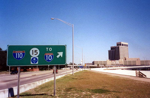
Eastbound on U.S. 90 at the joint southern terminus of I-110 and MS 15 (which duplexes for all 4 miles of I-110). Photo by Alex Nitzman, taken in September, 2000. |
Southern segment northern terminus
|
|
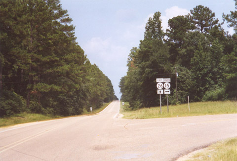
The Northern end of this segment of MS 15 is located in the Desoto National Forest at MS 26. Photo by Alex Nitzman, taken in August, 2001. |
Northern segment southern terminus
|
|
Westbound US 98 at the interchange with MS 15/198. This marks the northbound re-beginning of MS 15 as well as the eastern terminus of the Beaumont segment of MS 198. Photo by Alex Nitzman, taken in October, 2000. |
|
|
Within the interchange on the eastbound US 98 side. This scene shows the ramp from eastbound US 98 to northbound MS 15. Photo by Ed Wilson, taken in February, 2002. |
|
|
The on-ramp onto eastbound US 98 from MS 15/198. Photo by Ed Wilson, taken in February, 2002. |
Northern segment northern terminus
|
|
Entering Mississippi, where TN 125 transitions into MS 15. Photo by Adam Froehlig, taken in 1999. |
Back to Mississippi Highways
Back to Highway Pictures
Back to Highways Page
Back to Main Page
Last Updated: May 28, 2005
(C) 2005, 2004, Adam Froehlig