
Description
The Minneapolis "North Loop" was a proposed Interstate which would have created a full loop around downtown Minneapolis, connecting to I-94 and a proposed "Northwest Radial" freeway on the west, and I-35W on the east. Planning on the "North Loop" began as early as the 1940s, with an expressway-style (multilane divided, but with at-grade intersections) proposed at that time. Planning changed in the early 1960s, when the route started being planned as a freeway and was given an Interstate designation of I-335. I-335 received some federal money in the 1970 highway bill to purchase right-of-way and begin construction. The project got as far as completing about 90% of its ROW acquisition, as well as some grading for the interchange at I-35W (the reason for the funky "Evil Knevil-type" ramp NB and the lane drop SB just south of Johnson St). Pressure from public opposition began mounting in the mid '70s, and the route was eventually cancelled in 1978, with Interstate Substitution money being used for other projects in the area, including parts of I-394, the MN 610 bridge, and the Central Ave/Broadway intersection.
Some folks have made comments in recent years that maybe perhaps it should have been built after all. The biggest reason behind their argument is that it would have helped reduce the pressure on the I-94 Lowry Hill Tunnel. This has been in dispute, and one of the biggest reasons behind its cancellation was the perceived notion that it would NOT help matters at the Lowry Hill Tunnel. Having obtained maps of the original plan, I would have to agree with this opposition. The most utilized "travelsheds" that transit through the Lowry Hill tunnel are I-394 to I-35W traffic, I-94 West to I-35W South traffic, I-394 to I-94 East traffic, and I-94 through traffic (and all vice versas). The proposed I-335 would have created an alternative for ONLY the I-94 West to I-35W South traffic, and that would not have been the most direct way. One serious flaw that limited I-335's potential impact on Lowry Hill Tunnel traffic is that there were no direct connections between WB I-94 and I-335, or vice versa. Adding these connections to the design would have given I-394 to I-35W traffic an alternative to the Tunnel, which would have improved the overall system.
I-335 as planned would have been a 6-lane Interstate-standard freeway with full or partial interchanges at I-94 (partial), Washington Ave (partial to/from east), Marshall Ave/Main St NE (partial to/from west), University Ave/4th St NE (full), Monroe St NE (partial to/from east), and I-35W (full). The highway would have been built to continue west of I-94 as the never-built "Northwest Radial" freeway. Curiously, there were no connections planned between I-335 and MN 65/Central Ave.
History/Timeline
Additional history from a 1975 study is located on this page.
Froggie Suggests
Images (click on a thumbnail for a larger view)
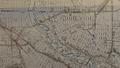 |
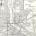
This ca. 1946 map shows some of the expressways and arterials that were proposed in Minneapolis at the time. The "North Ring" was proposed as an at-grade arterial, generally along 8th Ave NE between the river and Broadway, then along Broadway east to the then-proposed "Northeast Diagonal" (today's New Brighton Blvd). |
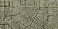 |
This 1964 map shows the first rendition of I-335. Note the almost-fully elevated proposal at the time, and how I-335 dipped onto the northeast corner of Nicollet Island. |
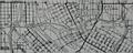 |
This 1971 map shows the several changes that were proposed in 1967, including new and/or relocated ramps, moving the alignment off of Nicollet Island, and the depressed section between Main St NE and 4th St NE. |
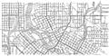 |
Further changes were made in 1972 by MHD, as shown in this 1973 map. Of note, the west end was redesigned due to cancellation of the Northwest Diagonal, and the remainder of the alignment between 4th St NE and I-35W was changed from an elevated section to a depressed section. |
 |
This 1975 map was included in the study mandated by the 1975 Minnesota Legislature on I-335. Oddly, this particular map shows ramps to/from the south at I-94, when none of the other official maps I've seen have included this configuration. |
Links:
![]()
Page last modified 24 February, 2008