Twin Cities Long Range Improvement Status
This page shows the both the long-range potential for improvement along the major Twin Cities highways, as well as my own suggested improvement potential
Maps
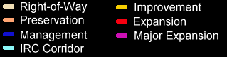
The first map below depicts improvement potential in the Twin Cities, based on existing funding streams, MnDOT Metro Division's Transportation System Plan (TSP) and the region's Long Range Transportation Plan. The second map depicts my own suggestions for improvement, provided additional funding can be secured.
Definitions
Right-of-Way: Right-of-Way preservation for a corridor. For the Existing map depicted below, this would only apply to a possible new river crossing between Shakopee and Chaska.
Preservation: Repair and replacement of roadway elements. Projects include sign and signal replacement, bridge replacement, resurfacing, and pavement reconstruction, but not full reconstruction with geometric improvements.
Management: Measures to optimize safety and efficiency. Projects include access management, Transportation System Management (TSM), Travel Demand Management (TDM), and Intelligent Transportation System (ITS) features. Also includes Preservation strategies.
Improvement: Generally considered a full reconstruction which includes preservation and management strategies as well as geometric improvements. May add limited capacity (usually in the form of auxiliary lanes), but major additional capacity is not added.
Expansion: Similar to the Improvement category, but either adds additional capacity in the form of additional lanes, or comprises new roadway construction on new alignment. Also defined by me as upgrading an existing expressway to a freeway.
Major Expansion: Not a MnDOT category, but one of my own. I define "major expansion" as expansion that either adds 2 or more lanes in each direction, or upgrades an existing expressway both by adding additional lanes AND converting that expressway to freeway.
Legend
Existing Improvement Map Through 2025
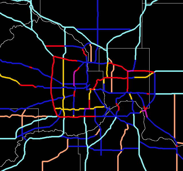
Froggie's Suggested Improvement Map
Click here to go to my suggested changes (Interstates).
Click here to go to the non-Interstates.
Click here to go to a map of 1996 traffic counts.
Click here to see graphics of my ideas for improving Twin Cities area
interchanges.
Click here to see my thoughts on a fantasy Twin Cities
transit
system.
Return to Twin Cites Highways
![]()
Page last modified 25 January, 2004