This page details the Twin Cities Streetcar System of my
overall fantasy transit system. This system uses the Minneapolis Streetcar
proposals (part of the
Access Minneapolis plan) as a baseline for core streetcar
system that supplements my fantasy Light Rail system.
A few of the streetcar lines proposed in the Access Minneapolis plan have been
replaced by fantasy LRT lines, while a few others were expanded, and two
streetcar lines serving St. Paul are included in this fantasy system.
The below table shows a quick description of the streetcar lines in my fantasy
system. Included are links to maps of each
corridor.
| Line Name |
Location |
Description |
Map Links |
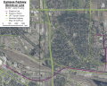
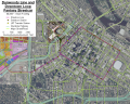
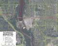
| Robbinsdale |
Robbinsdale Transit Center to Downtown Minneapolis |
Follows the Access Minneapolis
proposal for a streetcar along the Washington Ave N/West Broadway corridor. |
 |
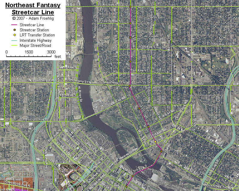
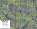
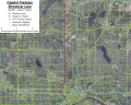
| Northeast |
Northeast Minneapolis to Downtown Minneapolis |
A north-south line through northeast
Minneapolis along University Ave NE. |
 |
| Dinkytown |
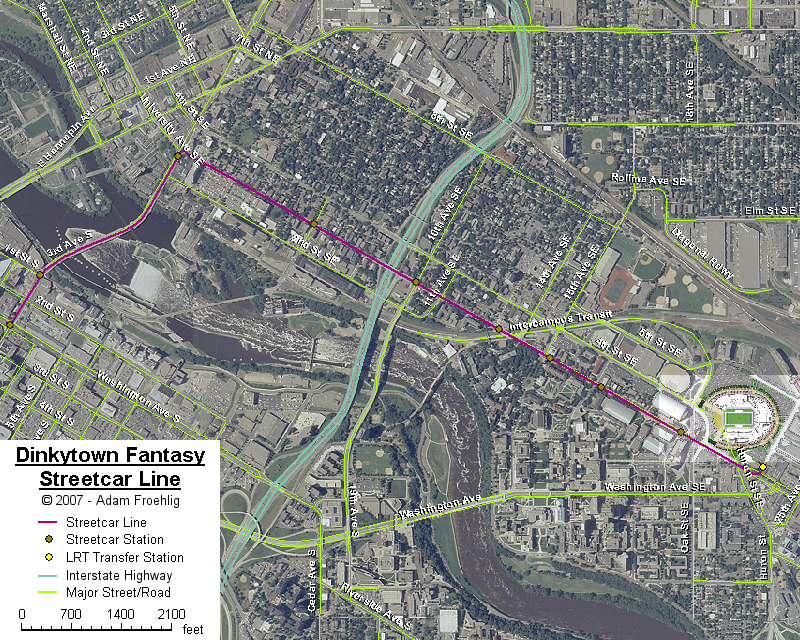
University of Minnesota to Downtown Minneapolis |
Follows the Access Minneapolis
proposal for a streetcar connecting downtown to the new Gopher stadium via
3rd Ave and University Ave SE. |
 |
| Campus |
University of Minnesota: East
Bank to St. Paul Campus |
This is my idea of a streetcar
replacement to the U of M transitway that connects the East Bank with the
St. Paul Campus, and would be an extension of the Dinkytown streetcar line. |
 |
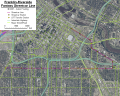
| Franklin-Riverside |
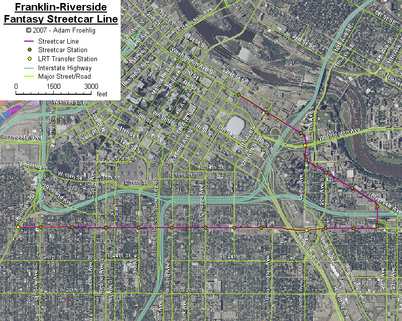
West Franklin to Downtown Minneapolis
via Cedar-Riverside |
An east-west route just south of
downtown Minneapolis, then loops back to downtown via the Cedar-Riverside
area. |
 |
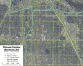
| Chicago |
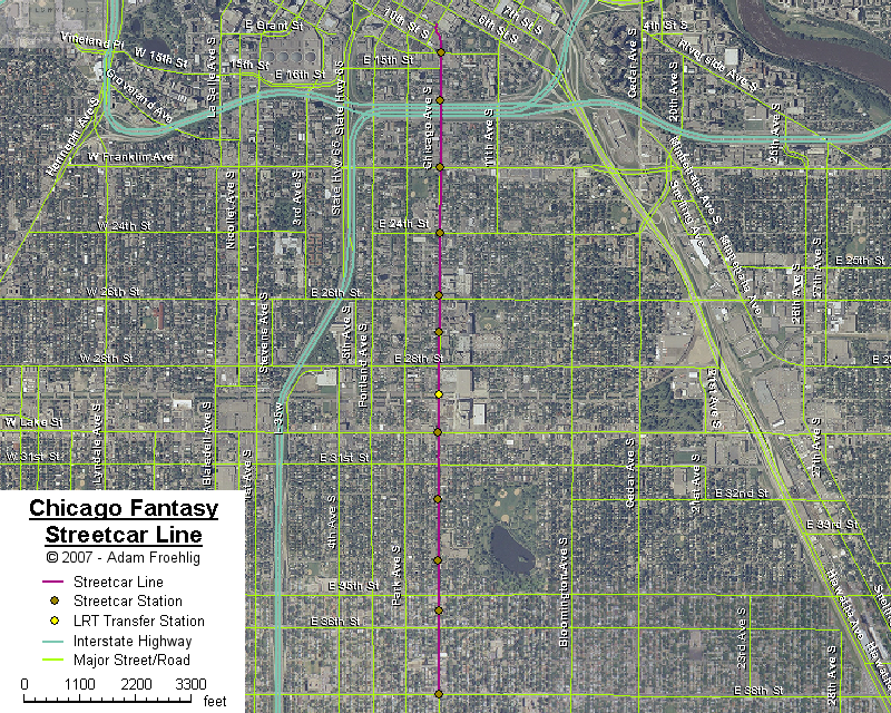
South Minneapolis to Downtown
Minneapolis |
Follows the Access Minneapolis
proposal for a streetcar along Chicago Ave. |
 |
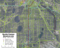
| Nicollet |
Richfield to Downtown Minneapolis |
Based on the Access Minneapolis
proposal for a streetcar along Nicollet Ave, but realigned at 46th St to
serve the 46th St station on my fantasy LRT
Lakeville Line, and extended south to the
Richfield "Hub" along 66th St. Also rerouted on the south side of
downtown to serve the Convention Center and align onto 3rd Ave through
downtown. |
 |
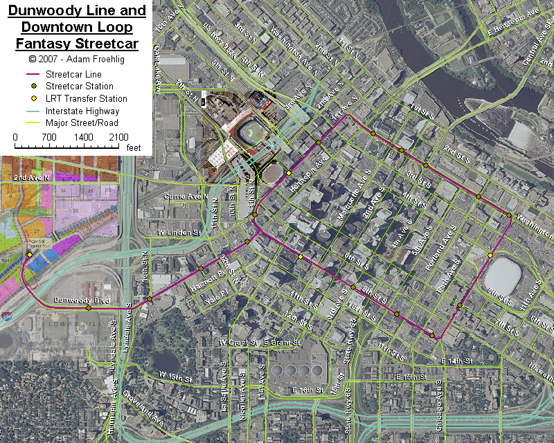
| Dunwoody |
Van White Blvd to Downtown Minneapolis |
A modification of the proposed
Hennepin streetcar. Since my fantasy LRT
Hennepin Line serves Uptown, I've rerouted
the proposed Hennepin streetcar to continue west along Dunwoody Blvd to Van
White Blvd, ending at my fantasy LRT
Southwest Line. |
 |
| Downtown Loop |
Downtown Minneapolis loop |
A loop around downtown Minneapolis,
utilizing Washington Ave, Chicago Ave, 9th St, and 1st Ave. |
| Snelling |
Highland Park to Roseville via St.
Paul Midway |
A north-south route in St. Paul mostly
following Snelling Ave. |
 |
| Ford |
South Minneapolis to Highland Park |
An east-west route connecting the
Hiawatha Line to Snelling Ave via 46th St
and Ford Pkwy. |
 |
| Capitol |
Downtown St. Paul to Little Canada |
A north-south line heading north from
downtown St. Paul via Rice St. |
 |
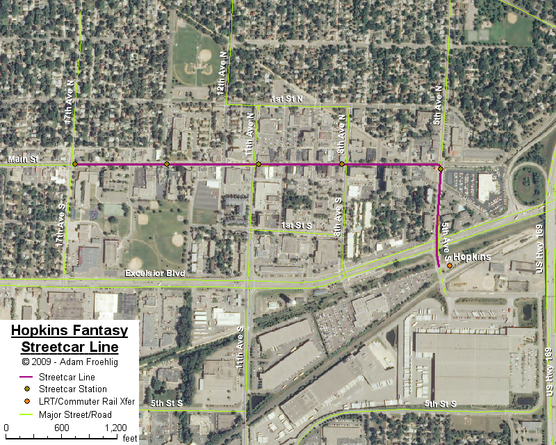
| Hopkins |
5th Ave S and Main Street in Hopkins |
Based on a Hopkins city proposal for a
trolley connecting the planned Southwest LRT station to the city's Main
Street. I've extended the streetcar west along Main Street to 17th
Ave. |
 |
The below chart shows a rough cost estimate for each line, based on a
planning-level cost of $25 million per mile and rounded to the next higher
million: