


Interstate Highway 20 in Mississippi
Skip down to Photographs
|
National Western Terminus: |
At I-10 east of Kent, TX |
|
National Eastern Terminus: |
At I-95 near Florence, SC |
|
National Distance: |
1,509 miles |
|
States Served: |
Texas, Louisiana, Mississippi, Alabama, Georgia, South Carolina |
|
Mississippi Western Terminus: |
LA/MS State Line at the Mississippi River in Vicksburg, Warren County |
|
Mississippi Eastern Terminus: |
MS/AL State Line near Kewanee, Lauderdale County |
|
Mississippi Distance: |
154.7 miles |
|
Counties Served: |
Warren, Hinds, Rankin, Scott, Newton, Lauderdale |
|
Cities/Towns Over 5,000 Population: |
Vicksburg, Clinton, Jackson, Pearl, Brandon, Forest, Meridian |
|
Highway Duplexes: |
US 80 (twice), US 61, US 49, I-55, I-59, US 11, MS 19 |
|
Junctions With: |
US 80 (multiple times), US 61, MS 822, MS 27, MS 22, MS 467, MS 855, Natchez Trace Pkwy, MS 18, I-220, US 49, I-55, US 51, Unmarked Highway (at US 49 South), MS 468, MS 475, MS 43, MS 13, MS 481, MS 35, MS 15, MS 503, MS 889, I-59, US 11, MS 19, MS 145, MS 39, US 45 |
|
Legislative Names: |
National Blue Star Memorial Highway
(LA/MS line to MS/AL line) 31st Infantry Division Memorial Highway (LA/MS line to MS/AL line) Travelers Highway (along US 80 duplexes) |
|
6+ lane segments: |
From I-220 to I-55 South Along I-55 duplex From I-55 North to MS 468 |
|
MDOT's Vision 21 System: |
High Priority from Mississippi River to US 61
North/MS 27 Medium Priority from US 61 North/MS 27 to Bovina Low Priority from Bovina to US 80 East at Clinton High Priority from US 80 East at Clinton to MS 18 Medium Priority from MS 18 to I-55 South High Priority from I-55 South to US 49 South Medium Priority from US 49 South to MS 468 High Priority from MS 468 to US 80 at West Brandon Low Priority from US 80 at West Brandon to MS 43 Low Priority from Chunky to I-59 South High Priority from I-59 South to MS 19 South/MS 39 Low Priority from MS 19 South/MS 39 to Toomsuba |
Average Annual Daily Traffic Volumes (2004)
|
Warren County: |
23,000 (At Mississippi River) |
|
Hinds County: |
30,000 (W of MS 22/Edwards) 31,000 (E of MS 22/Edwards) 33,000 (E of Bolton) 35,000 (E of Natchez Trace Pkwy) 41,000 (E of Old Raymond Rd/Exit 35) 54,000 (E of Spring Ridge Rd/Exit 36) 71,000 (E of I-220/US 49 North) 85,000 (E of Ellis Ave) 107,000 (W of Gallatin St) 114,000 (E of State St) |
|
Rankin County: |
114,000 (W of I-55 North) 104,000 (E of I-55 North) 85,000 (E of US 49 South) 64,000 (E of MS 468) 54,000 (E of MS 475) 36,000 (E of Crossgates Blvd/Exit 54) 27,000 (E of US 80/West Brandon) 22,000 (E of MS 43) |
|
Scott County: |
22,000 (E of MS 13) 22,000 (E of MS 481) 17,000 (E of MS 35) 17,000 (E of Lake/Exit 96) |
|
Newton County: |
18,000 (E of US 80/Exit 100) 18,000 (E of MS 15) 20,000 (E of MS 503) |
|
Lauderdale County: |
20,000 (W of US 80 West/Lost Gap) 22,000 (W of I-59 South) 35,000 (E of I-59 South) 50,000 (E of US 11 South/MS 19 North) 41,000 (E of 49th Ave) 58,000 (E of 29th Ave) 42,000 (E of MS 145/22nd Ave) 30,000 (E of MS 19 South/MS 39) 24,000 (E of Russell/Exit 160) 21,000 (E of US 11/US 80/Kewanee) |
Current/Upcoming Projects Listed in the STIP
|
Year: |
Location: | Type of Work: | Funding: |
|
2005 |
At Flowers | ROW for Interchange reconstruction | $1 million |
|
2005 |
Mississippi River to Bovina | Overlay | $8 million |
|
2005 |
Clinton-Raymond Rd to MS 18 | PE for 6-lane widening | $700,000 |
|
2006 |
Through Vicksburg | ROW for Reconstruction | $5 million |
|
2006 |
At Flowers | Interchange reconstruction | $5 million |
|
2006 |
At Clinton-Raymond Rd | Interchange reconstruction | $9 million |
|
2006 |
MS 468 to US 80/Brandon | 8-lane widening | $10.5 million |
Froggie's Notes:
- I-20 is a major
east-west Interstate across Mississippi, serving as a direct route between
Dallas and Atlanta.
- Sections of I-20 were under construction by 1960. The
first section to open was in 1964 from MS 27 in Vicksburg east to
Bovina. By 1971, most of I-20 was complete across
Mississippi, the only sticking point being through Meridian.
The section through Meridian was eventually upgraded to
minimal Interstate standards through the 70s.
- The pavement on I-20 between Brandon and Newton is often known for having a
roller-coaster effect. Despite several pavement reconstructions and
replacements, the problem has persisted. The underlying reason lies in the
ground itself, and the extensive amount of red clay in the region.
- Of note is that the Legislature placed the entire segment from the Mississippi
River to Brandon on the Vision 21 program.
- A currently underway project, Phase 3 of "The Stack", involves adding a
collector-distributor (C/D) road to the westbound side of I-20 between US 49
South and I-55 North at "The Stack" interchange just southeast of downtown
Jackson. The project also includes a flyover ramp from northbound US 49 to
westbound I-20.
Froggie Suggests:
- Provide at least 6
lanes between US 61 South in Natchez and US 80 at West Brandon.
- Widen to 8 lanes between I-220 and I-55 South.
- Widen the I-20/55 duplex to 10 lanes.
- Widen to 8 lanes from US 49 South to MS 475.
- Provide a full freeway-to-freeway style interchange at MS 475.
- In Lauderdale County, widen to 6 through lanes plus auxiliary lanes from I-59
South to US 45.
- As an alternative to widening through Meridian, an Interstate-grade southern
bypass of Meridian could be built instead, from near Lost Gap east to the
existing US 45 South bypass. I have dubbed such a bypass as
I-259.
- Interchange improvements and ramp additions as needed.
2004 Aerial Photos
All aerial photos are pulled from aerial imagery provided by the National Agriculture Imagery Program, via the Mississippi Automated Resource Information System.
|
|
I-20 crossing the Mississippi River between Louisiana and Mississippi. The bridge immediately north is an old combination road/rail bridge that used to carry US 80 across the river. Some ground photos of these two bridges can be viewed on this page. |
|
|
I-20 interchange with US 61 South in Vicksburg, just east of the Mississippi River. |
|
|
Two interesting interchange designs here along I-20. The east-west road is Clay St, and is the old alignment of US 80 through and east of Vicksburg. It now carrying the MS 822 designation, though it's unknown if it's signed in the field. MS 27 runs south from the interchange on the right, while US 61 continues north from the same interchange after a duplex with I-20. |
|
|
I-20 interchange at MS 22/MS 467 near Edwards. |
|
|
I-20 interchange at the hidden MS 855 near Bolton. MS 855 serves as a state-maintained connector from I-20 into Bolton. |
|
|
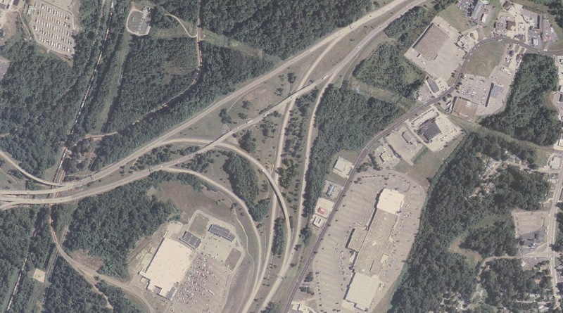
I-20/I-220 interchange in west Jackson. US 49 also passes through this interchange, from north to east and vice versa. |
|
|
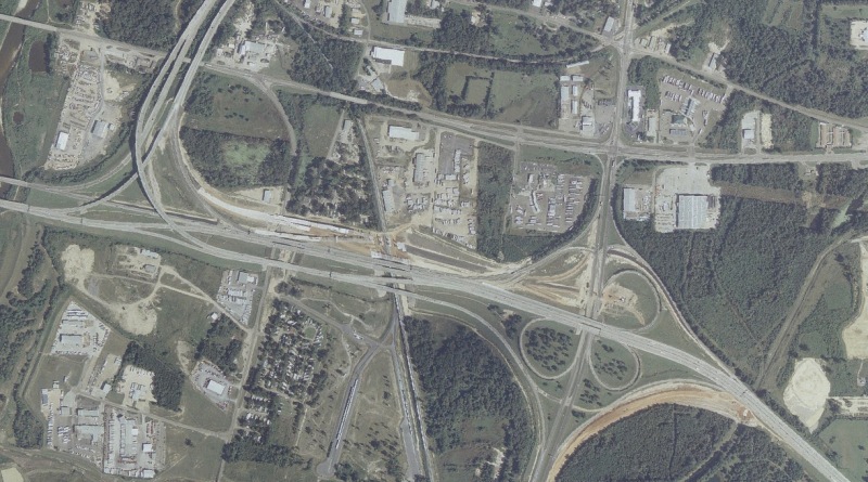
This tangle of ramps shows most of the I-20/I-55 duplex, with I-55 coming from the south in the bottom left, I-20 from the northwest, plus the older US 51 freeway stub partially between the two. |
|
|
Just to the east of the above aerial is the interchange locally called "The Stack", the interchange between I-20, I-55 North, and US 49 South. A project is underway, seen in this photo, to add a westbound C/D road to eliminate weaving issues along westbound I-20. The project will also add a flyover from northbound US 49 to the westbound C/D road. |
|
|
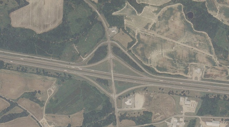
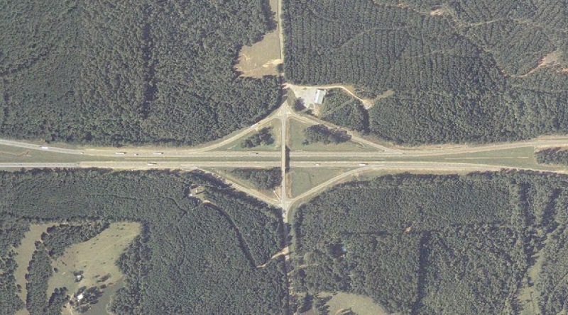
The I-20 interchange at Chunky, in eastern Newton County. MS 889 is a hidden route between I-20 here and US 80 in Chunky. |
|
|
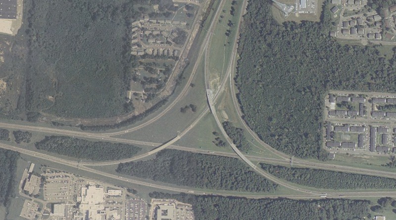
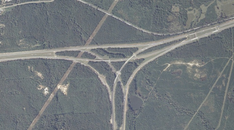
The interchange between I-20 and I-59 South, west of Meridian airport. This interchange begins a roughly 153-mile duplex between I-20 and I-59, stretching from here to Birmingham, AL. |
|
|
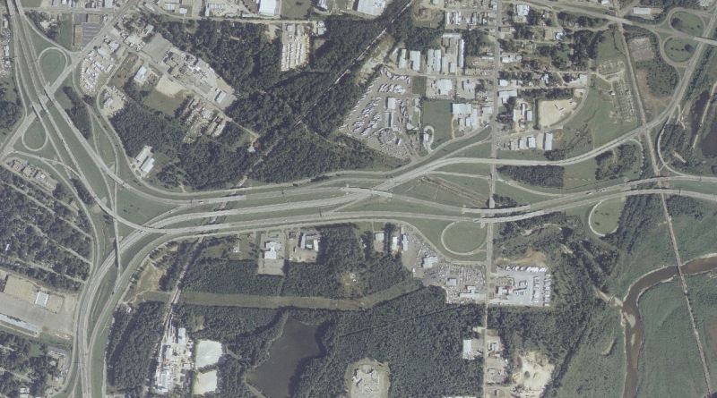
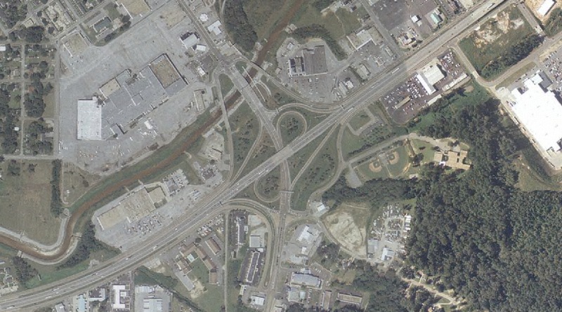
The I-20/I-59 interchange at MS 145/22nd Ave in Meridian. This interchange was originally built in the early 1950s along what was then a US 11/US 80 "bypass" of central Meridian, and was originally a cloverleaf. The 2 missing loops were taken out as part of the project to upgrade the road to minimal Interstate standards for I-20/59 in the mid 1970s. US 45 ran south from this interchange until the early 1990s. |
|
|
I-20/I-59 at the Mississippi/Alabama state line (delineated by the thin white line). The Alabama welcome center is on the right side of the image. |
Terminus Photos
No photographs available.
Other Photos
 | An older-style shild which includes the state name. Most interstate shields omit the state name, although older ones and a few of the brand new shields include it. Photo by Adam Froehlig, taken in 2000. |
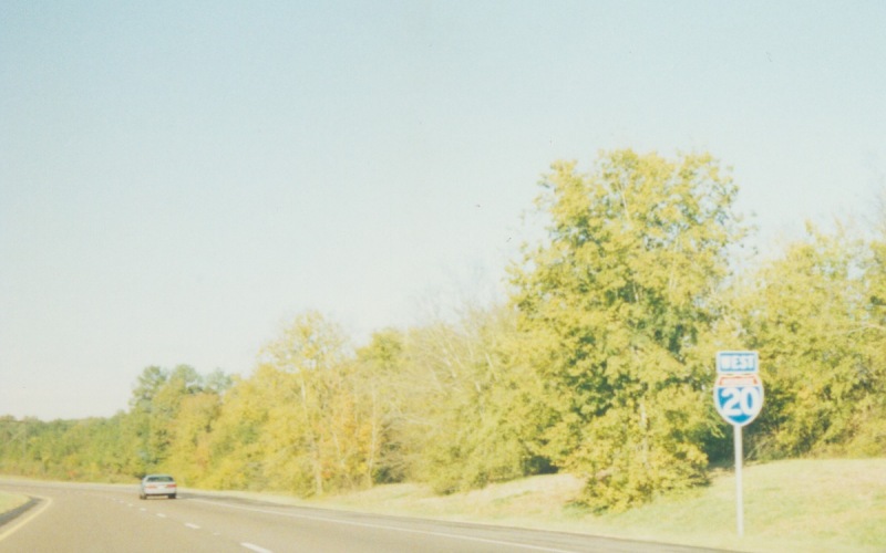 | A westbound shield that lacks the state name. This was just west of MS 43. Photo by Adam Froehlig, taken in 2000. |
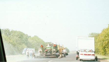 | A new overlay being laid on westbound I-20 in eastern Rankin County. Photo by Adam Froehlig, taken in 2000. |
 | Eastbound I-20/I-59, between MS 19/MS 39 and US 45. Photo by Adam Froehlig. |
 | Overhead guide signage westbound on I-20/I-59. The interchange with US 45 is a cloverleaf. Photo by Adam Froehlig. |
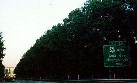 | Guide signage along eastbound I-20 in western Lauderdale County, a few miles west of Meridian. Photo by Adam Froehlig. |
Back to Top
Back to Mississippi Highways
Back to Highway Pictures
Back to Highways Page
Back to Main Page
Last Updated: May 17, 2005
(C) 2005, Adam Froehlig